Geospatial Foundation
Cesium, GIS, 3D Tiles, satellite data, terrain, CAD/BIM, and urban layers give the model precise binding to the real territory.
Error
An error occurred during the request.
Nothing was found
Try to change the query
We design digital twins for cities, districts, and infrastructure territories: geodata, buildings, roads, cameras, UAVs, utilities, safety, social assets, and ESG scenarios are brought together in a unified engineering 3D environment.

Solution essence
A smart city digital twin combines geodata, buildings, roads, cameras, sensors, utility networks, social assets, and service-operation scenarios. In this model, teams can see in advance what will happen during new construction, road closures, utility accidents, mass events, or autonomous transport launch.
Cesium, GIS, 3D Tiles, satellite data, terrain, CAD/BIM, and urban layers give the model precise binding to the real territory.
NVIDIA Omniverse and OpenUSD make it possible to assemble an urban scene, transport, cameras, UAVs, sensors, and physically plausible scenarios.
NVIDIA Cosmos and analytical models help generate rare situations, synthetic data, and forecasts for services, transport, and video analytics.
Solution Architecture
The architecture is built not around one attractive map, but around connected urban data, a 3D scene, rules, analytics, simulation, and an operator loop. This approach makes it possible to test decisions before real changes are made in the city.
Cadastre, GIS, terrain, orthophotos, 3D Tiles, coordinate base, and territory boundaries for precise positioning of all objects.
Buildings, roads, intersections, networks, cameras, stops, social assets, risk zones, and development projects in one visual environment.
Traffic flows, sensors, video analytics, requests, service statuses, CAD/BIM models, regulations, and external information systems.
Testing of closures, accidents, mass events, construction, service routes, UAVs, and load on urban infrastructure.
Event recognition, deviation search, load forecasting, synthetic data, and operator decision support.
Monitoring panels, map layers, statuses, event logs, reports, manual scenario checks, and a clear operating picture for city services.
How the Project Works
The project can start with one district, transport corridor, industrial territory, or industry layer. The model is then expanded with data sources, scenarios, KPIs, and interfaces for administration teams, services, and operators.

We define the territory, users, applied scenario, data scope, and result: transport, utilities, safety, urban planning, ESG, or an integrated model.
We connect GIS, CAD/BIM, road schemes, cameras, sensors, requests, network data, asset passports, traffic flows, and service regulations.
A building, road, intersection, school, network, camera, vehicle, incident, and development project become digital entities with attributes, relations, and history.
We combine geometry, semantic layers, movement of transport, people, UAVs, cameras, weather conditions, and response scenarios.
We compare development options, calculate KPIs, forecast load, identify risks, and prepare recommendations before city decisions are implemented.
We configure layers, roles, reports, and operator screens so the digital twin becomes a working tool for urban teams.
Urban Layers
Layers can be implemented separately, but the strongest effect appears when they are connected: a new object immediately shows its load on roads, networks, schools, ecology, budget, and safety.

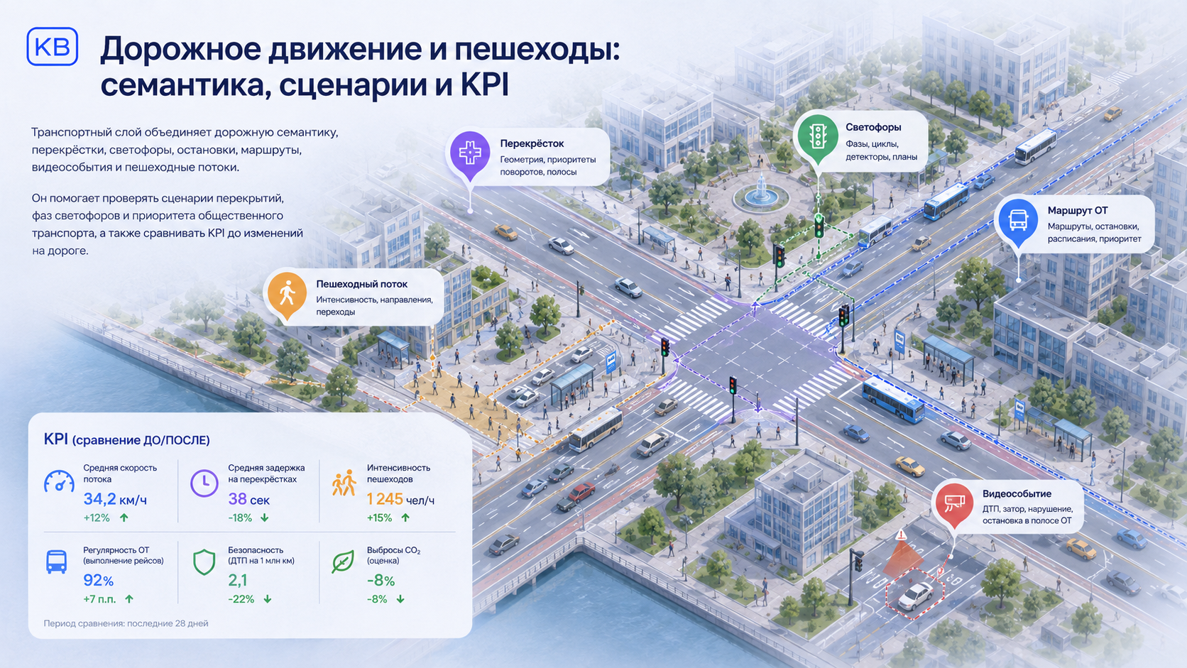
The road-traffic digital twin combines road semantics, intersections, traffic lights, stops, routes, video events, pedestrian flows, and a simulation model.
It can test closures, roadworks, traffic-light phase changes, public transport priority, autonomous route launch, and the impact of new interchanges before real roadworks begin.

The utilities layer connects buildings, networks, meters, central heating substations, transformer substations, container sites, municipal vehicles, requests, accidents, and work orders. This helps model outages, cleaning, flooding, waste collection, and reserves for critical assets.
The safety layer combines cameras, incidents, service routes, evacuation, mass events, and risk zones. The social infrastructure layer shows capacity and load of schools, hospitals, public service centers, sports facilities, accessibility, deficits, and resident routes.

The urban-planning layer connects the master plan, land-use and development rules, parcels, constraints, red lines, restricted-use zones, development projects, timelines, BIM/IFC, and the impact of new assets on roads, networks, schools, ecology, and citizen requests.
The ESG layer turns the digital twin into a decision-testing system: district indices, risks, resilience, ecology, transport, energy, waste, social infrastructure, and budget impact are shown in one management loop.
Visual Assets
Visual materials help quickly explain the composition of a digital city: planning scenarios, traffic flows, city services, safety, social infrastructure, and sustainable development.



What We Can Build
The project can be light and pilot-based: 2.5D layers with attributes for a district or corridor. Detailed 3D/BIM is added where presentation, precise simulation, critical assets, and AI training matter.
Flows, queues, traffic lights, roadworks, closures, public transport priority, and before/after scenario comparison.
Networks, accidents, cleaning, solid municipal waste, requests, vehicles, work orders, reserves, and load forecast for utility infrastructure.
AI cameras, incidents, service routes, evacuation, mass events, risk zones, and response-time control.
Master plan, constraints, projects, social infrastructure, ESG indices, and load testing for the urban environment.
You can start with one applied layer: transport corridor, utilities, safety, social infrastructure, urban-planning project, ESG dashboard, or UAV scenarios. The model then expands into a unified urban 3D environment.
Need help? Contact us in any convenient way.
Support specialists are available around the clock and are ready to help with any questions.
Message us on Telegram. We will reply shortly.
Describe your request in detail using the feedback form.